Groundwater atlas for the Surat Basin
This research resulted in the creation of a 3D Water Atlas - an online integrated 3D visualisation system that enables environmental managers and regulators to assess groundwater conditions, identify inconsistencies in data, manage impacts and risks and make more informed decisions about coal seam gas extraction, waste water extraction, and water reuse.
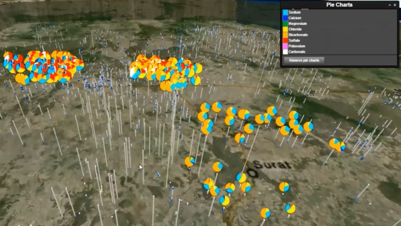
The 3D Water Chemistry Atlas is an intuitive, open source, web-based system that enables the three-dimensional (3D) subsurface visualisation of groundwater monitoring data, overlaid on the local geological model (formation and aquifer strata).
SOME OF THE BENEFITS & USES
- Open source, easy to use
- Single source of separate data types
- Information supporting projection of risks and operational costs:
- Associated with water treatment
- Water re-use options
- Other risk indicators - Wider availability of QA/QC’d data and analytical tools
- Adding value to legacy datasets
- Integrated view of geological models and water chemistry
- Single bore or regional comparisons
- Statistical and geochemical analysis tools
- Geospatial analysis
- Time-series analysis
- Capability to assess changes in water chemistry as fields become operational
- Communication tools for community liaison
FEATURES INCLUDE
- Virtual globe navigation – including map imagery and terrain
- Ground push” to expose the subsurface geological features
- Visualisation and search of bores – provided by Groundwater Database Tables
- Visualisation of geological subsurface models
- Browsing metadata of bore registration, stratigraphy, casing, aquifer and water analysis as well as other data attributes
This project was delivered across two main phases:
Phase 1: Feasibility study & development of database and prototype software tools. The technical feasibility study was completed to determine if there is sufficient groundwater quality data available to develop a Water Chemistry Atlas with the capability to address key technical questions regarding regional water quality trends and provide valuable information to government, industry and the community. The Feasibility Study provided an assessment of the data quality and extent and the level of analysis that the data can support. Key steps included:
- Developing a test database structure for the Atlas and use of a subset of data from the Office of Groundwater Impact Assessment (OGIA) water quality database for trial purposes.
- Using a range of geochemical graphical techniques to analyse the water quality data.
- Superimposing these analyses on a geological model of the region, which is based on data regarding factors such as location, depth and formation layer.
- Using spatial, geological and temporal trend analysis (including a trial of 3D visualisation software) to determine if there are any patterns in water quality either within a coal seam or between a coal seam and other aquifers.
- Identifying the best software to maximize access to data and results for researchers, industry professionals and the public.
Phase 2: During phase 2, the scope of the Atlas was enlarged from the pilot sub-region to the full extent of the Surat Basin and the prototype software tools were refined to improve performance. Additional datasets were added and new visualisation, analytical and reporting tools were developed. Protocols for database access, sharing, security and maintenance were also developed to ensure that the integrity of the data and outputs from the Atlas are maintained to a high standard.
PROJECT OUTPUTS
-
Online cloud based portal: 3D Water Atlas Online Portal.
- Journal article: Describing the developed 3D visualisation system used in the 3D CSG water atlas; Hunter J, Brooking JC, Reading L, and Vink S (2015) A Web-based system enabling the integration, analysis and 3D sub-surface visualization of groundwater monitoring data and geological models, International Journal of Digital Earth, 9(2), 197-214.
- Conference presentation: Underschultz J, Vink S (2015) Emerging Complexity of the GAB Aquifer Systems in the Surat Basin, AAPG ICE 2015.
- Conference presentation: Underschultz J (2015) What are the impacts on groundwater from CSG development in the Surat Basin? A fast tour through some of the science, Queensland Gas Conference 2015.
|