Objectives
The aim of this project is to develop an open 3D sub-surface visualisation interface to an integrated ground water knowledge-base that provides an effective communication tool for CSG stakeholders (industry, government and community groups), project partners and the general public.
The specific aims of the 3D CSG Water Atlas project are to:
- Develop a unified, quality controlled database of groundwater chemistry data that is integrated with a reliable and consistent geological model, together with other freely available and relevant geospatial layers (e.g. satellite imagery, road networks, property boundaries and mining lease boundaries).
- Develop new visualisation and analysis tools which take advantage of the super-position of water chemistry data and 3D geological data.
- Develop a Web interface that enables access to spatial and temporal water chemistry data and increases public awareness of water chemistry trends whilst protecting commercially sensitive data.
- Identify existing gaps in data and knowledge that can be used to guide future monitoring practices.
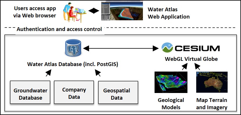
Technical details
Groundwater data assessment, analysis and visualisation
- Access groundwater database and the Office of Groundwater Impact Assessment (OGIA) data.
- Review data quality and structure to determine appropriate data inclusion, structure and visualisation.
- Perform review of QA/QC methods and develop an automated QA/QC procedure for groundwater chemistry data.
- Preform a review of statistical and geochemical methods of data analysis to determine which methods would be appropriate to include into the Atlas.
- Incorporate statistical and geochemical analysis methods, such as summary statistics, Piper diagrams and pie charts to support geochemical interpretation.
- Overlay satellite imagery, property boundaries, mining lease data etc. to aid navigation.
- Collate metadata and other associated information for presentation in the Atlas.
Database Development
- Develop a common data model in consultation with companies and OGIA.
- Implement appropriate data security (authentication and access controls) to the integrated datasets.
- Establish a PostGreSQL database with PostGIS indexing.
- Upload all datasets into the PostGreSQL database.
- Develop search, browse and filtering services over the underlying datasets.